Todd Rightsell shares his list of top shots, top hikes, top drives, top campgrounds, and more top recommendations for truck camping in Yosemite National Park.
If we had a matter-to-energy transport in our house, we would most certainly beam ourselves to the National Parks on a regular basis. A quick peek at Mount McKinley before breakfast? Yes, please! A lunch time stroll around the majestic trees of Sequoia? Absolutely! A mid-afternoon bubbling mud pit in Yellowstone? Twist my arm! After dinner with El Capitan glowing in the Yosemite sunset? Beam me there!
Each and every one of these places should be carved deep into your bucket list. In fact, all of the National Parks should be penned onto your personal pail of imperative plans.
Over the past seven years, we have been incredibly fortunate to have visited dozens of National Parks and every one is guaranteed to blow your mind in one way or another. Speaking of minds, Yosemite National Park, in particular, is a no brainer. Don’t think about going to Yosemite, just go.
To launch your journey, or to inspire your return, truck camping adventurer Todd Rightsell shares his top Yosemite photographs, hikes, drives, campgrounds, boondocking sites, and more. It starts here with Todd. With any luck, you’ll end up in Yosemite.
| Click here to see Todd’s Travel Tips for Yosemite National Park |
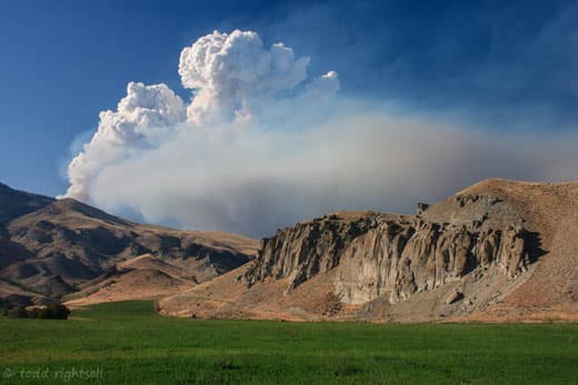
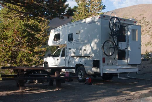
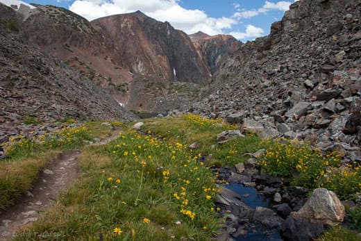
After finally making it to the notch it was time to head to Yosemite for a month. There is no good way to get from Glacier Park to anywhere, much less the Sierras. It took me four days of driving, but I took my time. With scenes like this it is easy to see why. This was taken in Idaho along the Salmon River.
I had been driving through smoke all day from this fire and when I got on the other side of it I was treated to a clear view of the smoke plume. The Salmon River is incredibly beautiful and Idaho may be the best kept secret in the United States. It has some unbelievable scenery. I could definitely live in Idaho.
Yosemite. Even the name is beautiful! This was the second time I had been to Yosemite National Park. The first time was in May of 2005. At the time, the high country of Tuolumne Meadows was still under twelve feet of snow. So this was the first time I had actually been over Tioga Pass and into the high country at Yosemite.
Tuolumne Meadows is magical. I spent two weeks here at the campground at 8,600 feet and made the most of every day. There is so much to do and see up here that you could spend a lifetime exploring, and many have, and still not see it all.
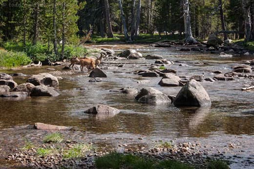
I’m a big fan of Ranger hikes and programs. On this particular day I was out with a ranger led group along the Tuolumne River when we spotted these deer. We all just watched in silence and marveled at the sight as they crossed. Pretty cool.
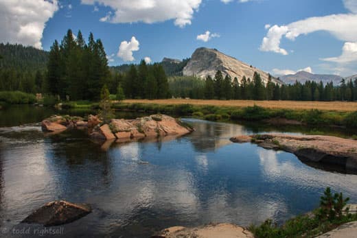
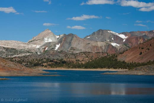
This is Lembert Dome standing guard over the Tuolumne River and Tuolumne Meadows. Tuolumne Meadows is the largest alpine meadow in the Sierras and it is one of the prettiest landscapes I have ever seen. The road to get up here doesn’t open until late June most years and, by early October, the season is pretty much done. Life happens quickly up here.
The valley floor is about 8,600 feet. Lembert Dome rises another 900 feet higher but the views from the top are well worth the vertigo you may suffer on the climb up. It’s not for the faint of heart as it is a bit dicey in spots.
After a couple of weeks in the campground at Tuolumne Meadows, I relocated to the valley floor. Crowded as the place is, it’s still one of the best spots on Earth. Yosemite Valley is about seven miles long and every inch of it is packed with world class scenery. It’s like sensory overload. Everywhere you look is something that in and of itself would be a worthy centerpiece of any national park if it were located anywhere else in the world. It is that good. Most of you will recognize this iconic rock. This photo was taken from the valley floor loop trail which I hiked the first day I arrived.
The valley floor loop trail is a good hike to take upon arriving in the valley, as it takes you past every major feature in the valley and is an easy, but long walk. The whole loop is about fourteen miles, but you can do shorter variations.
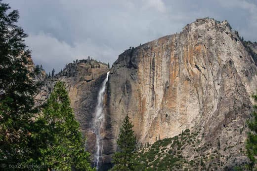
This is Yosemite Falls, the tallest waterfall in North America and sixth tallest in the world. The scale of this waterfall is hard to imagine. It plummets over 2,400 feet and the noise can be deafening. It makes the ground shake beneath your feet, but in a good kind of way. To place it in perspective, the Empire State Building is 1,454 feet high and 102 stories. 2,400 feet is nearly half a mile. It’s a huge waterfall.
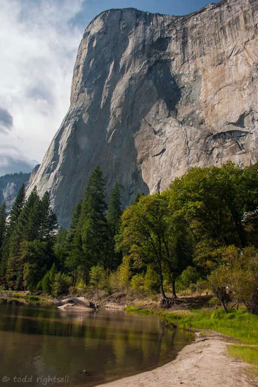
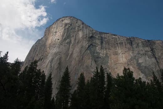
This is the famous El Capitan wall as seen from the valley floor. This is one of the tallest vertical walls in the world and looms nearly 3,000 feet over Yosemite Valley. For rock climbers, this is Mecca. Many of the modern day climbing techniques and most of the equipment used today was developed here.
There is a climbers camp near the base and it’s always full of unique and very colorful characters. The typical ascent of this granite monolith takes four to five days. Imagine sleeping on a fifteen inch wide platform suspended 2,500 feet above the valley floor!
You can’t see them in this photo, but there are two climbers on the wall about half way up. From the ground they were barely visible without binoculars. That’s a bit too crazy for my taste. This photo was also taken from along the Valley Floor Loop Trail.
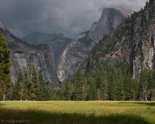
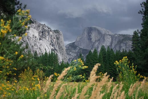
Another shot of Half Dome from the valley floor. Although the clouds made for a nice picture, I was still about four miles from the campground and was hoping the rain would hold off. Thankfully it did.
If you look closely, you can see a face on the rock. Legend has it that the face is that of an old indian woman who lived in the valley. She and her husband had an argument and they were both turned to stone for their bad behavior. Her husband is facing her across the valley floor.
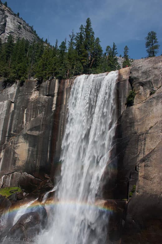
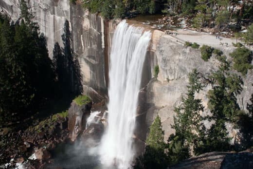
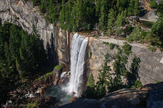
Vernal Falls is another of Yosemite’s famous sights. This is a 400 foot high waterfall along the John Muir Trail, which arguably may be the most scenic trail in the world. For scale, note the person in the red shirt standing on the edge to the right of the falls.
This place was really crowded, and I hate crowds, but it was so amazing that it was worth it anyway. I was lucky to get to see it flowing this strong. Often by this time of year the flow has been reduced to a trickle and sometimes to nothing at all. It all depends on how much snow falls in the winter. The rainbow was an added bonus.
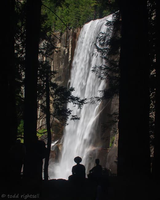
Another shot of Vernal Falls. I couldn’t resist the silhouette effect and snuck around behind this unsuspecting couple to get this picture. It turned out to be one of my favorite shots of the summer.
After climbing the Mist Trail to the top of Vernal Falls, I headed even higher still along the John Muir Trail. This section of the trail was fresh tracks for me and I was amazed at the view of Vernal Falls from above. It’s a pretty good uphill trek from the top of the falls to here, but the view you are rewarded with from above is nothing short of spectacular.
Just a few weeks before I took this picture two people got washed over the falls and died. Apparently they decided to go swimming in the Emerald Pool which is visible in the upper right corner just above the falls. Not only did they have to ignore common sense, but also the fence and the signs that say no swimming along with an explanation of how swimming here can be hazardous to your health. Unfortunately, this happens almost every summer.
The day I was there it was a very serene and calm looking pool, but it can be deceptive, especially earlier in the season when the snows are melting and the currents are stronger. This summer in Yosemite seventeen people died, most from drowning while attempting to cross ice cold streams which were running faster than they thought.
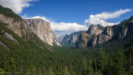
This is one the most famous views in Yosemite. Most of you will probably recognize this as being taken from Tunnel View. I have been up here several times but this is probably the best shot I have managed to get yet. That Carolina Blue sky just makes the whole scene. El Capitan is on the left, and Half Dome in the distance. Bridal Veil Falls is visible on the right.
This is another good example of a hanging valley. You can see the flat valley above Bridal Veil Falls and imagine how the glacier that formed it was literally carved off by the much larger glacier which formed Yosemite Valley, leaving the cliff face behind. Nature is a force to be reckoned with for sure.
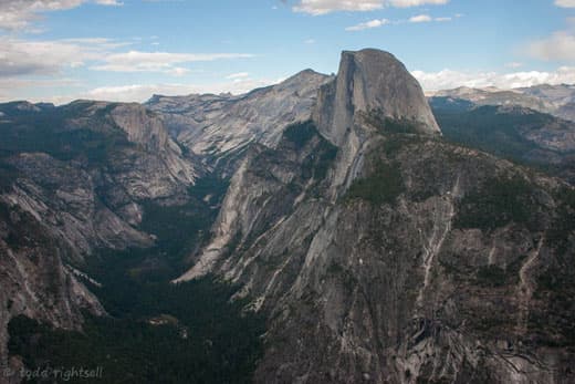
This was taken from Glacier Point, which is perched on the canyon walls high above Yosemite Valley. The views from up here are dizzying, and standing here it’s hard to imagine the forces that carved this landscape. To the right of Half Dome are Vernal and Nevada Falls. For a sense of scale, each of those waterfalls is about 400 feet high. The sheer vertical face of Half Dome is about 1,300 feet. It’s a huge chunk of rock!
If you want to see something incredible, go on YouTube and search for Alex Honnold, who has free climbed the face of Half Dome with no ropes, just a bag of chalk and a lot of nerve!
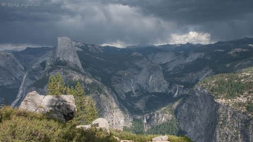
Tuolumne Meadows and the high country of the Sierras can be seen in the distance. Storms at Glacier Point can be intense. I was a little too late and got there just as this one was clearing. Nonetheless, the lightning bolts off in the distance were spectacular.
From this perspective you can see just how deep and flat Yosemite Valley really is. The walls are nearly vertical in most spots, and range from 2,000 to 3,500 feet high. Several years ago they had a huge winter snowpack and big rainstorms in the spring. The two combined for an epic flood which literally filled the valley like a bathtub to a depth of about twenty feet. That’s a lot of water.
This shot was taken while peering over the wall at the observation platform from the top. If you fell from here you would literally fall 3,000 feet to the bottom without hitting a rock before you splattered in the food court at Curry Village! You can also see the face of Tessiak, the old indian woman, on Half Dome. Cloud’s Rest is the point in the far distance to the left of Half Dome. Out behind that is Tuolumne Meadows.
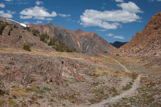
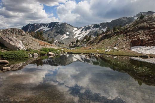
After about twelve days in Yosemite Valley it was time to start thinking about heading home. I still had two more things on my list to see before leaving the Sierras for good, and Twenty Lakes Basin in the Hoover Wilderness was the first.
It’s easy to see why. This is Saddlebag Lake, which is the jumping off point for exploring the Hoover Wilderness. This is only about a one hour drive from Tuolumne Meadows and another well kept secret. There is a campground just above the lake that has awesome views, if you get the right site, which I used as my base for a couple of days while here.
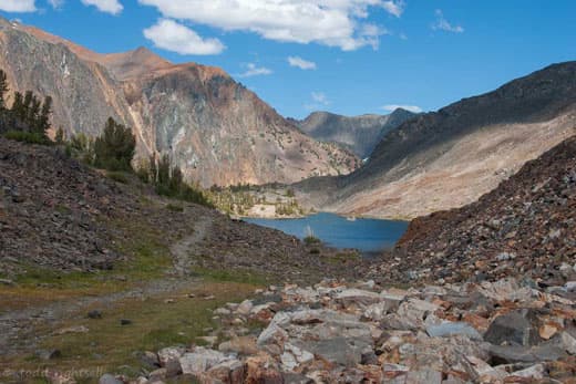
On the far end of Saddlebag Lake is the trailhead that leads into this area. If you are lazy, in a hurry, or both, you can catch a boat shuttle for a few bucks from the general store and restaurant at the campground to the far end of the lake. From there the loop is only about five miles and you will pass seven lakes and see some of the most beautiful alpine scenery you can imagine. This is a highly recommended detour from Yosemite and the crowds.
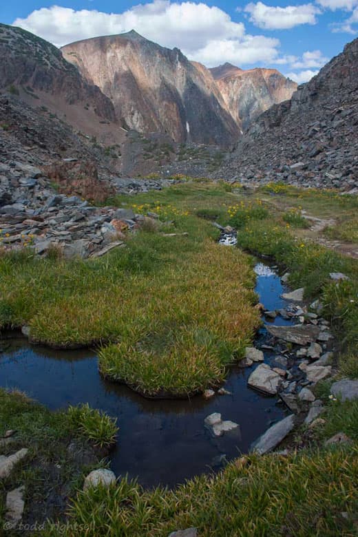
Another typical view along the trail in Twenty Lakes Basin. The colors in the rocks were brilliant. Every step got better and better.
Every time I thought I had seen the best the place had to offer, I would come over a small rise and see something like this stretched out before me. More than once I just stopped dead in my tracks to soak it all in.
More from Twenty Lakes Basin. This might be the best hike I have ever been on in terms of sheer in your face scenery. It’s short at about five miles if you take the boat shuttle, pretty much flat, well as flat as the High Sierras can be, and full of views like this.
You will pass seven lakes if you stick to the trail. If you care to venture off trail a bit there are thirteen more lakes to see! And those are just the named ones. A word of caution though. The trail becomes very faint and a bit hard to follow towards the outer end of the loop. I had a bit of trouble following it and got sort of turned around a little and ended up off trail. For a few minutes I was a bit nervous, but then I saw some folks on the trail in the distance and picked it back up again. So just be aware of where you are and try to keep your tongue from dragging on the ground as you walk!
Here’s another one from Twenty Lakes Basin. This was nearing the outer end of the loop and not too much further down the trail is where I lost it. Everything worked out okay though and I managed to get home safely!
This is the last one from Twenty Lakes Basin. This is one of my favorite pictures from all my trips. I like the reflection and the contrast between the rocks and the snow. I sat here for a long while and just thought about what an awesome adventure I had been on for the past 100 days and how lucky I was to be able to pull it off. I know it sounds cliché, but I felt like I was on top of the world and I literally wasn’t far from it!
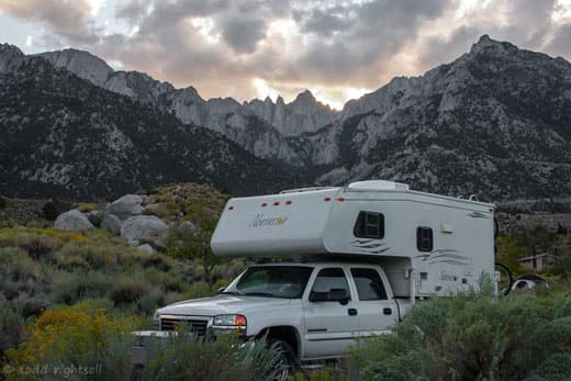
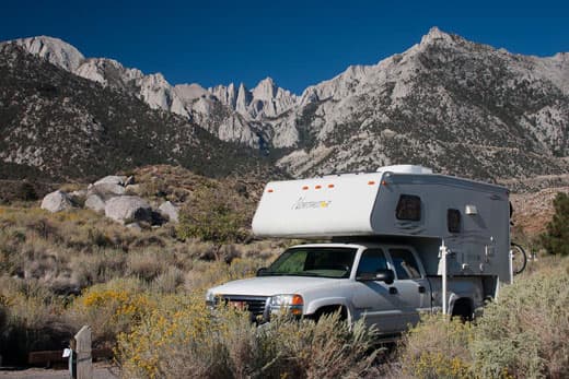
After leaving Yosemite and the Twenty Lakes Basin it was time to head home. The only thing missing on my list was Mount Whitney, the highest point in the continental United States. I drove to Whitney Portal and got a campsite with a great view of Whitney and waited for sunset. Well, sunset was a bust because of the clouds, but I still had sunrise the next morning. It was not a bad campsite for my last official night out before making the mad dash home to North Carolina.
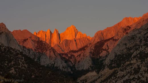
The next morning I got up very, not sort of, early and was treated to a magnificent view of Mount Whitney bathed in the early morning sun. It was an awesome sight. Whitney soars to just over 14,000 feet and is the crown jewel of the Sierras.
There is another campground several miles further up the road from where I was, just behind the highest part of the tree line in the center of the photo. I had intended to get up there for a night, but I was forced to turn back as my rig simply would not pull the hill! That is the first time that I have ever had to turn back in the Northstar.
I had been driving for about seven miles up a pretty good grade and had it in first gear and making about twelve miles per hour when I passed a sign saying I had a little more than seven miles to go. The temperature gauge was rising and I wasn’t even to the really steep switchback sections yet. Not wanting to destroy a perfectly good truck, I turned back and went to the lower campground. This is not recommended for larger truck campers. You guys in the pop-ups can probably roll right up there, but not larger rigs. Nonetheless, I was happy with my decision when I was treated to this view the next morning.
From here it was a five day cross country trek back to North Carolina and home. I hated to head back east. The first day on the road is always the worst, but I had been gone for 108 days and honestly was ready to see my family again. Plus I had to get back to work and replenish the coffers for this summer’s trip.
| Yosemite National Park – Todd’s Travel Tips |
| Top Hikes:
Yosemite is the Holy Grail for day hikers and backpackers in the United States. The Sierra Nevada mountains offer up some of the best scenery in the world. Several of the most famous hiking destinations in the world are here, and Yosemite National Park is the centerpiece. Try one of these walks below and I am sure you will agree. And as always, don’t forget your camera!
Above: This shot was taken from a section of the John Muir Trail. Its a pretty brutal climb to get up to there, but well worth it. The falls themselves are 317 feet high. This was taken in September, so I was lucky to see any water at all. I have seen it in May with five times as much water. Earth shaking. 1. Vernal and Nevada Falls via the Mist Trail If you have the stamina, this is a don’t miss. It is all uphill. If you have ever been to Yosemite Valley, you know you can’t walk too far in any one direction before you have to start climbing. That is just the landscape. But this hike is worth the torture. It starts at Happy Isles and winds along the mighty Merced River for about two miles to Vernal Falls; a picture perfect 400 foot waterfall. Along the way be prepared to get wet, as the mist coming off the falls can often seem like a torrential rain. Take rain gear. Be extremely careful here, as the rock steps can get very slippery and falls are common. At the top is Emerald Pool, a deceptively gentle but dangerous pool just above the precipice of the falls. Do not swim here. Many folks have died trying it. If you can go a mile or so further, you will be rewarded with a view of Nevada Falls that you will never forget. On the return trip, when you get back to the Emerald Pool, take the John Muir Trail back down. Firstly because of the staggering views of Vernal Falls from high above and secondly because you don’t have to walk back down the Mist Trail with weak legs. Like I said above, it can be very slippery. 2. Valley Floor Loop Trail This is a great and leisurely way to see Yosemite Valley. There is no official trailhead but the entire loop is about fourteen miles and passes every major feature in the valley; however, you can do as much or as little of it as you feel like. If you get tired, just walk to the nearest shuttle stop and take it back to your campsite or Curry Village (or anywhere else in the valley you care to go). You won’t regret this one. 3. Cathedral Lakes Cathedral lakes is one of my favorite hikes in Tuolumne Meadows. As luck would have it, the shuttle stops at the trailhead. Again, this one is mostly uphill on the way and downhill coming back. Your reward for all this effort is a stunning view of Cathedral Mountain from the shore of Cathedral Lake; a view you will not soon forget. Round trip is six to seven miles. I did this walk with a Ranger led group and had a blast. I know I say it often, but the Ranger led hikes are a great way to enjoy the parks.
Above: El Capitan in Yosemite. It was taken from the valley floor along the Merced River from the Valley Floor Loop Trail, a fourteen mile loop through Yosemite Valley that passes every major feature in the park. El Capitan is the tallest wall in North America, and one of the tops in the world. It is about 3300 feet straight up. Top Drives: Yosemite National Park and the surrounding area has some spectacular drives. If you have time to venture out, try one of the half to full day trips below. Your tired legs will thank you for the break. So gas up the truck and hit the road! 1. Tioga Road Tioga Road is the east entry road into Yosemite, and it is spectacular. This is one of the best mountain passes I have ever driven. If you arrive from the east you will have to cross Tioga Pass to get into the park. Try not to drive off the road while you rubberneck at the scenery. Along the way are pristine alpine lakes and meadows along with several trailheads which allow access to the remote Hoover Wilderness and Inyo National Forest. Plan ahead though, as this road doesn’t open most years until well into June and can close at any time due to weather. By late September you are taking your chances on this one. This is truly high mountain scenery. 2. Glacier Point Glacier Point Road starts just outside of Yosemite Valley and winds higher and higher until you reach the Glacier Point overlook perched some 3,000 feet above the floor of Yosemite Valley. The view from Glacier Point makes you dizzy. Literally. You can peer over a small chest high railing and see all of Yosemite Valley below you. Be careful, the first step is a doozie! If you were to fall from here, you would literally fall close to 3,000 feet before landing on the valley floor. Now that’s an “E ticket” ride for sure!!! 3. Valley Floor Open Tram Tour The best thing about this drive is that somebody else does the driving and narration. This is one of the coolest things I did in Yosemite Valley. The open air tram bus has no roof (this is key as everything is up from the Valley floor) and will take you past all the major attractions in the Valley. It costs a few bucks, but it is well worth it. Again, you will learn a lot about Yosemite and its history. Reservations/tickets can be purchased at Curry Village or any of the lodges in the Valley. Yeah, it is sort of a touristy thing to do, but it was one of the few touristy things I have really enjoyed.
Above: Saddlebag Lake campground is on the edge of the Hoover Wilderness. This is not in Yosemite, but just outside the boundary as you go over Tioga Pass and head down to the east. Hoover Wilderness is adjacent to the park. It is one of the top three prettiest areas I have ever been in. Top Campgrounds/Boondocking Spots: Yosemite National Park has several campgrounds suitable for truck campers. I like to play things by ear and rarely make reservations for a campground, but reservations are essential in Yosemite Valley and highly recommended in Tuolumne Meadows. Without them, you run a very high risk of getting shut out of the park. Get them early though, as they go on sale four months ahead of your arrival date and they will sell out, usually within minutes. For the whole scoop and to reserve a site go to www.recreation.gov. Although I have not stayed in all of them yet, my favorites so far are: 1. Tuolumne Meadows Tuolumne Meadows may be my favorite campground of all time. It is probably because I had so much fun the first time I camped there. In my line of work, real estate appraisal, location is everything, and this place has it. It sits in a forested area along the Tuolumne River at about 8800 feet. It is just a cool place to be. Tuolumne Meadows is one of the best spots in the world. It’s almost magical in a sense. If you miss Tuolumne Meadows then you have missed some of the magic of Yosemite. While they do hold half of the sites for first come/first served, I recommend making a reservation for peace of mind. Its a long way to alternative sites if they are full when you arrive. 2. Upper Pines There are three campgrounds in Yosemite Valley. The largest is Upper Pines and in the valley, I like this one the best. Lower Pines can be a bit stinky if the wind is blowing the right way as it sits beside the horse stables. Lesson learned! Upper Pines is situated on the Merced River in a flat forested section of the valley. It’s an easy bike ride to most of the famous spots in the valley and a short way from Curry Village, which has some of the best pizza you’ll ever eat, especially after a grueling day on the trail. And of course the shuttle stops here too. 3. Boondocking The Sierra mountains are full of great boondocking spots. In addition, while not technically boondocking, there are several Forest Service campgrounds located along Tioga Road just west of Mono Lake/Lee Vining. If you get shut out of Tuolumne Meadows or need a spot to make an approach to Tuolumne Meadows from, this is it. The first one you come to is about two to three miles west of Lee Vining and is actually called Lee Vining. I like this one best because it’s a pretty safe bet you can get in and you can get a wireless phone signal here. 3G no less! I know…I know….most of you could care less about a 3G phone signal. But when you have a business to run and you are out for months at a time, the G in 3G stands for gold!
Above: This photo was taken at the foot of Mt. Whitney at the Lone Pine Campground. Again, not in the park actually, but on the road to the Whitney Portal Trailhead. Mt. Whitney is the highest point in the lower forty-eight. This is actually on the east side of the Sierras about 150 miles southeast of Yosemite. The most famous section of the John Muir Trail (argueably the most famous trail in the USA) starts in Yosemite (and goes right past Vernal Falls and Half Dome) and ends at Mt. Whitney. Other Recommendations: 1. Mono Lake Mono Lake lies just east of Yosemite National Park at the foot of Tioga Pass, and is a great place to explore before coming into the park. The best word to describe Mono Lake is weird. Stop by the visitor center there and see for youself. You can also view it from a distance from the Mono Lake Pass trail out of Tuolumne Meadows; a beautiful seven to eight mile round trip walk. 2. The bus is a plus! Like several other parks, Yosemite National Park offers a free park shuttle to help alleviate traffic in both the valley and on Tioga Pass Road through Tuolumne Meadows. And just like other parks which offer similar service, it is one of the best things about Yosemite. The valley shuttles stop at every major attraction and campground in the valley while the Tuolumne shuttle runs between the numerous trailheads on Tioga Road in the high country. They even have a big shuttle bus (Greyhound style) to take you back and forth between the valley and Tuolumne Meadows. You can literally park the truck for your entire stay. 3. Two Parks Yosemite is really like two parks in one. Yosemite Valley is located at about 4500 feet and is famous for its iconic rock formations and waterfalls including Half Dome, El Capitan, Vernal and Nevada Falls, Yosemite Falls, etc. In contrast, the Tuolumne Meadows area is a vast open sub-alpine meadow and one of the largest in the United States. At nearly 9,000 feet, the scenery here is very different from in the Valley. If you can only make the trip once in your life, try to plan for a time when Tuolumne will be open, usually early July or later. That way you can see both areas. But don’t wait too long, as the campground at Tuolumne Meadows usually closes by late September. 4. Take your bike. Yosemite Valley is very crowded and parking or driving in the valley is a real pain. A bike is way better. The valley is basically flat, and riding here is a real treat. After all, you are riding through one of the most fantastic landscapes on the planet. You can easily ride to every major attraction in the valley from your campsite. Trust me on this one. If you don’t already have a bike rent one for the time you are there. 5. And as always and this almost goes without saying, have fun! |