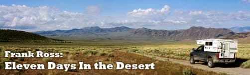
Frank Ross takes his Hallmark Milner LX 2,300 miles exploring the desert in search of petroglyphs, old mines, and rock hounding. He found much, much more.
With a week and a half to explore Nevada, I couldn’t wait to get going. I wanted to see as much as I could in the time I had, spending every night in a different place. I had a lot of fun planning the trip, going over maps, the internet, and researching old copies of Desert Magazine. I had a general outline of where I was headed with lots of options on places to explore. On the menu for this trip are petroglyphs, old mines, and rock hounding.
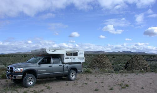
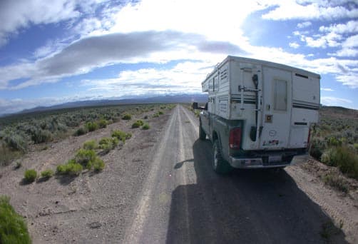
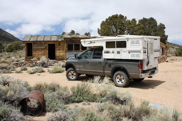
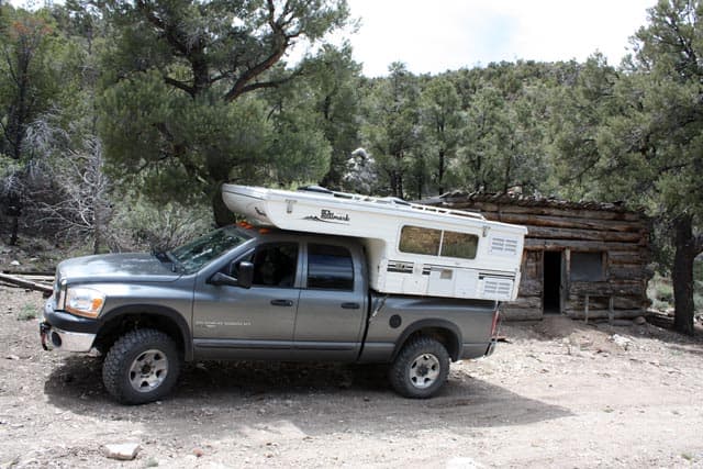
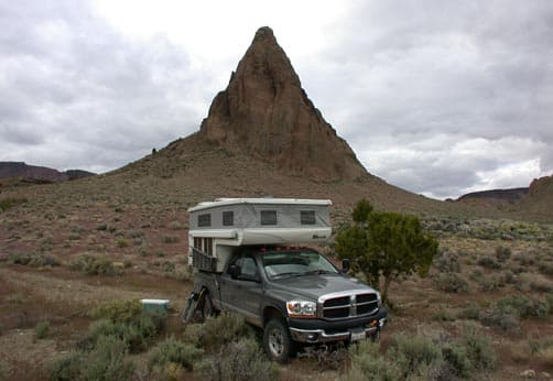
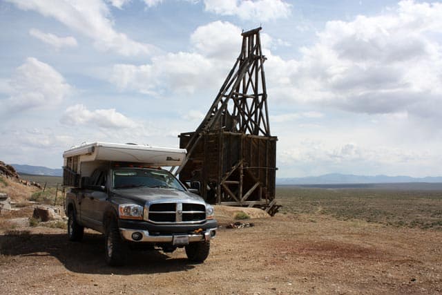
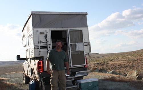
ABOVE: 2006 Dodge Power Wagon with his 2005 Hallmark Milner LX
When traveling alone (one vehicle) out in the desert, or anywhere far from help, you need to be well prepared. My truck is a 2006 Dodge Power Wagon with 25,000 miles, so it’s still in the reliable stage of life. One of the necessities for the trip is a tire patch kit. On a prior trip out in the boondocks, I had two flat tires and would have been in a bind without a tire patch kit. You need a good twelve-volt compressor to compliment the patch kit.
A SPOT satellite messenger is a must. With it, you can summon emergency help, send two different canned e-mail messages, or summon roadside assistance. Also, family and friends can track your location on the internet. If you’re stopping at the Mustang Ranch, you might want to disable that feature. Cell phones can’t be relied on so the SPOT can be a life saver.
A good first aid kit and a snake bite kit are in my rig. I also carry a well-stocked tool kit and recovery gear to go along with the winch on my Power Wagon.
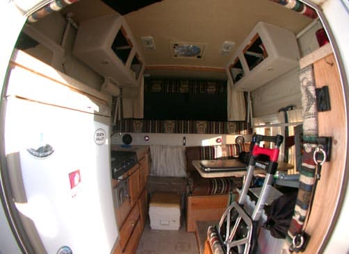
My 2005 Hallmark Milner LX carries twenty-two gallons of water. I’m good there.
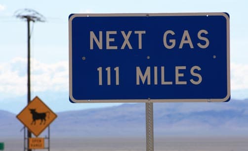
One last tip; never pass up a gas station, you want to have as much fuel as possible when you head to the outback.
The Nevada state line is only four hours away from my home on the coast near San Francisco. Shortly after leaving Reno, it’s like you’ve turned back time. You can drive the two lane roads for long stretches without seeing another car and the vistas are grand. Once you leave the pavement, human encounters are even more of a rarity.
Just this year, a Canadian woman was rescued by hunters after spending seven weeks in her van that got stuck on a logging road in north eastern Nevada. Her husband left for help on day three, and has not been found. If they had a SPOT, they would have been rescued in hours.
For navigation, I use a laptop computer with topographic software and a USB port GPS receiver on the dash. I also bring a hand held GPS for hiking plus some good old fashioned paper maps. Some words of caution when using a GPS; the computer can pick a route for you, but it might not be the best route. That’s what happened to the Canadian couple.
I discovered several stops on this trip by skimming through old issues of Desert Magazine. The magazine was published from 1937 to 1985. All issues are available online at scribd.com or dezertmagazine.com/old-desert-magazine. It’s a wealth of information on the deserts of the Southwest. The old ads are fun too including ads for early truck campers.
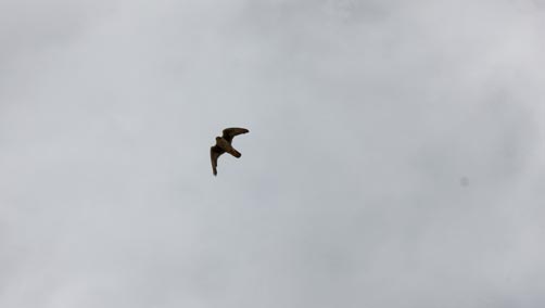
My first stop was a place called, “The Sump”, a beautiful geologic area west of Tonopah with petrified tree stumps. I found this spot in Desert Magazine, April, 1973. While exploring the area, I walked up to the edge of a high cliff to take a picture and startled a bird that took off and began circling me, screeching, trying to drive me away. I snapped a few photos and got out of its space quickly. My guess was a Falcon. I later confirmed it was a “Prairie Falcon”.
I did some four wheeling in and around the Sump looking for a campsite out of the wind and made camp. In Nevada, you can camp just about anywhere you want because most of the land off the beaten path is Bureau of Land Management land or National Forest land.
 |
 |
 |
 |
 |
 |
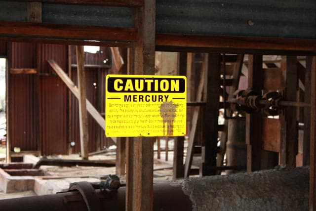
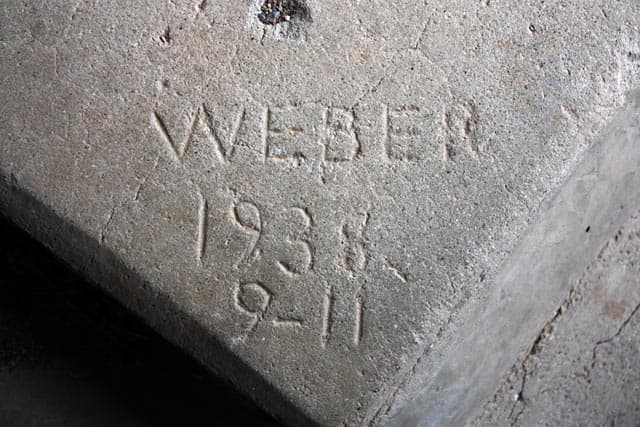
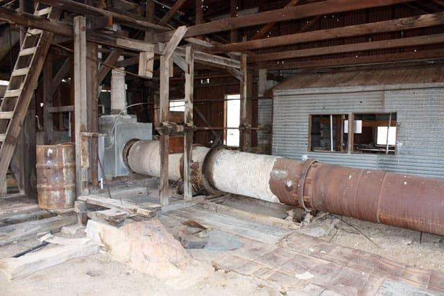
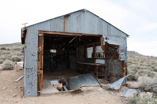
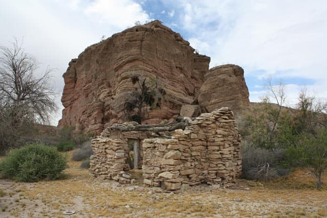
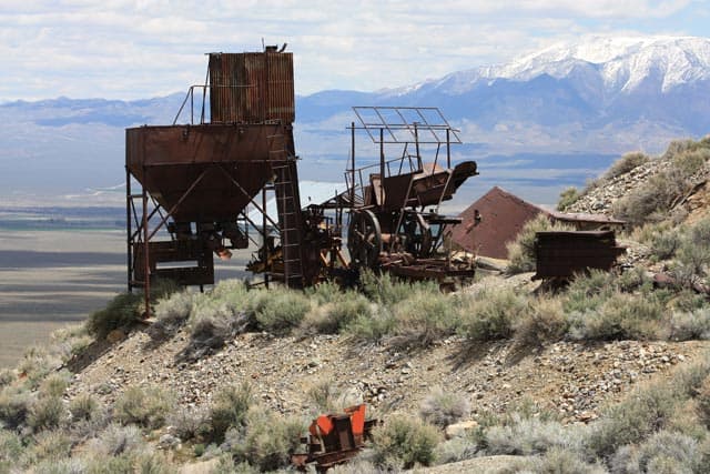
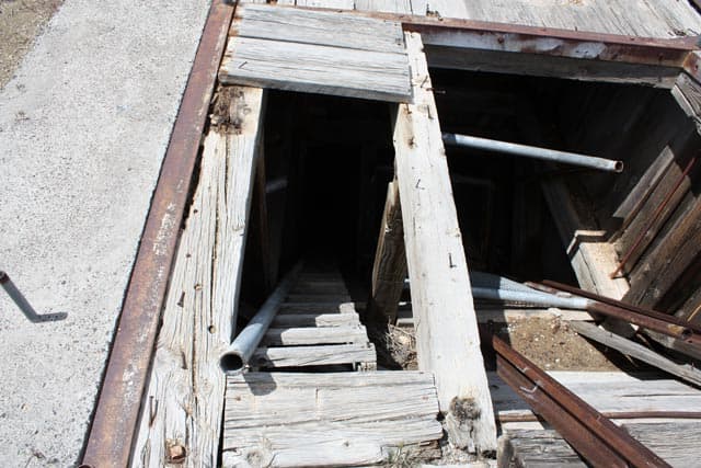
Next up was Red Rock Mine from Desert Magazine, February, 1956. This Mercury mine was different from other mines I have visited because I knew so much of its history after reading the Desert Magazine article. There were many small buildings and a lot of the mining equipment is still there. I wondered what eventually happened to the family that owned the mine.
 |
 |
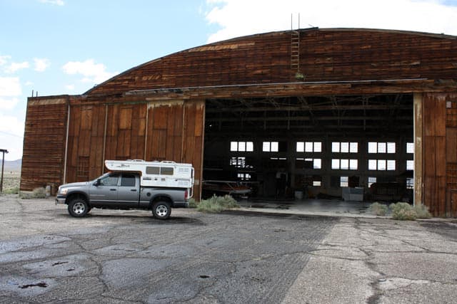 |
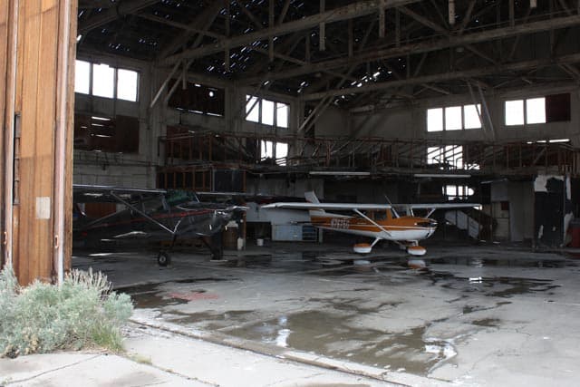
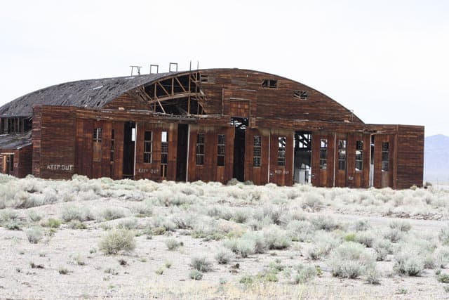
I then headed east through Tonopah stopping at the airport to check out the old wooden World War II aircraft hangars. An airport employee said to feel free to look around, but warned me that the big hangar was not safe. Every time they have a wind storm they expect it to come down. I camped nearby in the Toiyabe National Forest.
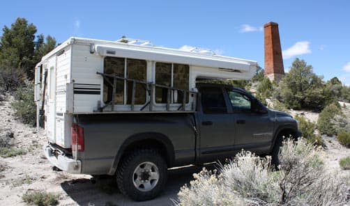
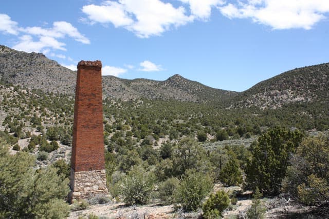
In the morning, after passing Rachel, Nevada, I left the pavement headed to the old Crescent Mill site. While taking pictures of the mills brick chimney, the quiet of the desert had given way to jet fighters playing overhead. This ended with a double sonic boom.
 |
 |
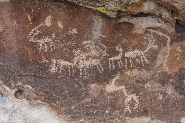 |
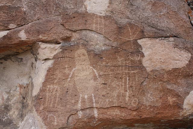
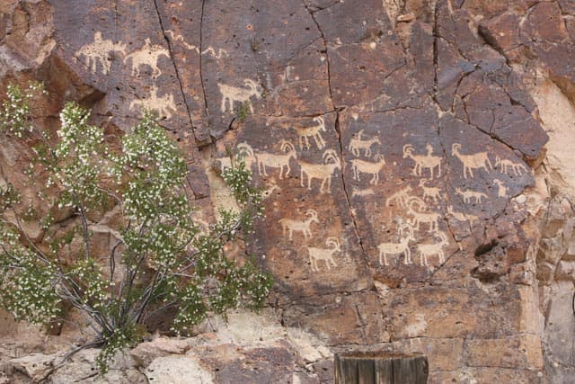
Next stop was Mount Irish Archaeological Area. The road through the mountains got very narrow in spots with a lot of branches imparting new “desert pin striping” down the sides of my truck. Mount Irish is a well known petroglyph area, and the BLM has a register and maps there for a self-guided walking tour of the area.
 |
 |
 |
The road in from the east is bumpy but fine for cars. Not far away is another area of petroglyphs called the White River Narrows. It is narrow in places but there’s no river to be seen. It’s right off of Highway 318 north of Hiko. This is a beautiful area with lots of petroglyphs. After exploring the area, I made camp surrounded by old Indian art.
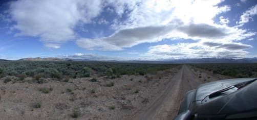
ABOVE: Highway 318 to Highway 93
In the morning, I headed east across the desert for twenty-five miles from Highway 318 to Highway 93 stopping at the Bristol Charcoal Kilns along the way. Then, near the town of Pioche, I went up a Canyon to, “The Big Trees”; Desert Magazine, September, 1962. Here in this canyon are just a few big Redwood trees. And no one seems to know how they came to be here in this micro climate in the desert. They are hundreds of miles from where they grow in California.
I then headed to Rainbow Canyon near Caliente. On the way, I got pulled over by Nevada Highway Patrol for speeding. After a mild scolding, I was sent on my way without the $262.00 ticket. Thank you sir.
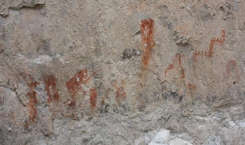
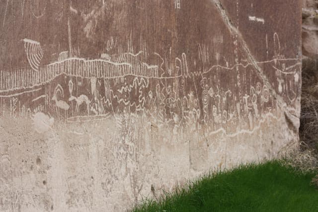
Rainbow Canyon is a beautiful area and prone to flash flooding. The Union Pacific Railroad runs through it and twice in the last several years their tracks and the road has been heavily damaged by the water. In this canyon you can find pictographs which are very rare. Pictographs are painted and Petroglyphs are scratched.
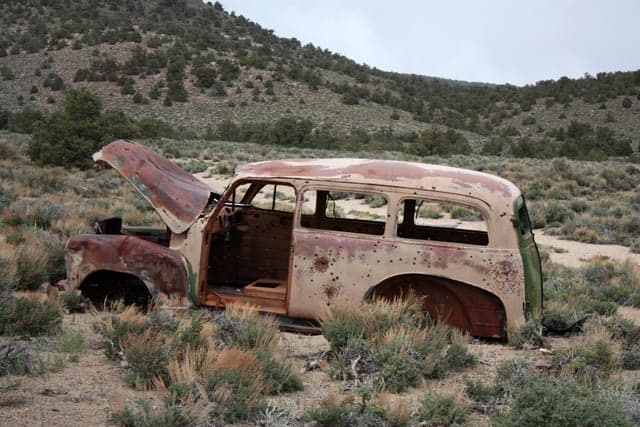
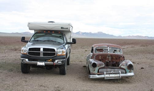
The next morning it was snowing. The ten day forecast said it would be seventy-five degrees. After filling up the water tank and getting some supplies in Caliente, I headed to the ghost mining town of Del Mar; Desert Magazine, January, 1954. There were old rock walls and mine works and the obligatory old car full of bullet holes.
 |
 |
 |
Then I made a quick run south to Moapa and turned north up Meadow Valley Wash ten miles to an old cabin I researched on the internet just before leaving home. There was a picture of the owners standing in front of the cabin in the early 1900’s in the article and it told of many petroglyphs behind the cabin. I had to do a little trespassing on the railroad right of way to get within a half mile of the cabin. Then I walked through thick brush and a creek for pictures of, “Huntsman’s Cabin” and the petroglyphs.
I was getting paranoid about getting back to my truck and getting off the railroad right of way before a train came by. In my hurry, I tripped and fell flat on my face cutting the tip of my nose and a finger. After cleaning up with a couple of baby wipes I hightailed it out of there and headed back north on Highway 93 to the Pahranagat National Wildlife Refuge.
Earlier on my way south, I had noticed a campground next to a lake and I thought I’d check it out. It turns out this National Wildlife Refuge campground was free and all the campsites are lake front! It was a beautiful area, the campsites were spread out, and you can paddle on the lake but no motorboats or swimming are allowed. The only drawback to this place is its proximity to the highway.
The next day I went to two more Indian rock art sites, Ash Springs and Crystal Wash. After exploring these areas I decided to head north to the Austin area to an abandoned turquoise mine. Like most of this trip, I had no idea where I would camp for the night, but that makes it more exciting.
While driving north on Highway 375, I noticed a beautiful canyon a few miles west of the highway. All I needed was to find the road into it. A couple of miles further, I turned onto a two track road and went up into this canyon. I found a single small tree near the end of the road next to a series of pointed mountains.
On the map it was appropriately called “Fang Ridge”. There was a water hole nearby which means wildlife sightings were possible.
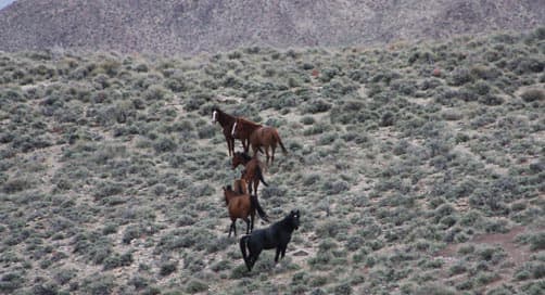
I had just finished jockeying my truck around, and using the rear air bags to get the camper level when six wild horses appeared from behind a small bluff. They were obviously heading to the water hole, but when they saw my truck they became very curious. They checked me out for a bit as I was taking pictures through the window, but I needed to get out for a clear picture. When I got out and they saw a human figure, they took off. They were beautiful healthy looking horses and I felt a bit guilty about keeping them from a drink.
I try not to camp too close to water holes. Maybe I’ll camp a little further away next time. The following morning I headed back to the highway and spotted the horses again about two miles away still giving me a wide birth.
I stopped in Tonopah to get gas. Then I headed north up, “Big Smokey Valley” on Highway 376 and, just before Highway 50, I took a dirt road headed southeast. About twenty miles later, I turned onto a two track trail. It was time to fold in the mirrors and prepare for more paint scratches as I tried to find the abandoned Indian Blue Turquoise Mine.
I knew from research that the mine was shown to a man in 1925 by his Indian servant. I thought I’d poke around in the mine tailings for some turquoise scraps. After a few miles of steep, narrow, and rough trail, I finally came to the mine. I parked next to an old shack and headed up to the diggings.
 |
 |
 |
As I approached the mine itself, I saw a really new looking Location Monument. The monument had a container attached to it that held claim papers. It turns out that, just last year, a new claim had been made on the mine.
When I left the mine it was mid-afternoon and time to scout out a campsite. I headed south down Monitor Valley with the National Forest off to my right. Looking at canyons and the map, I went up a trail that followed a creek called Stoneberger. After couple of miles, I came to a creek crossing about twenty-five yards across. I thought long and hard about the ramifications of getting stuck, but crossed my fingers and went for it. Just on the other side was a beautiful place to camp. No guts, no glory!
The next morning, after giving the truck another bath, I went to the geographic center of Nevada which happened to be close by. After paying my respects to Nevada’s belly button, I went to the Town of Austin for supplies, then on to Buffalo Canyon off Highway 722. This remote spot is a place where you can find common Opal.
After turning off the highway and then turning off the dirt road onto a trail, I spotted a man by a car. This was the first human I had run into in the outback. He looked friendly. I didn’t see a lot of tattoos or anything, so I waved. He waved back and we ended up talking for half an hour. It turns out he’s a gold miner and he was here with an excavator doing some prep work for his partners on the mine. He told me where I could find the opal and off I went rock hounding. After collecting a pail of opal I said my good-byes to Dave the gold miner, and headed to Fallon for the night and a hot shower.
 |
 |
 |
The next day I backtracked to the east on Highway 50 to Highway 361 and headed towards Gabbs. Just north of Gabbs, I headed west into the mountains where my rock hounding book said I could find Fluorite in the tailings of the Kaiser mine. This was a large mining operation at one time. All the wooden structures where no longer standing and there were deep mine shafts everywhere. A lot of old mines shafts are surrounded with short barbed wire fences for safety, but you still need to be on your toes.
I was exploring some old foundation work when I heard a strange noise. When I spotted the source, all I saw was a tail with rattle attached going into the bushes. After gathering my wits, I gave the rattler a wide birth. This was my first encounter with a rattlesnake in my many visits to the desert and I told myself to be more alert.
I did collect some Fluorite and then went a short distance to Broken Hills, another mining area. At the old mines I saw many new claim markers. I guess with gold at over $1,500 an ounce, many old gold producing areas are getting a second look. I found some Opalized Petrified Wood in this area and did some target shooting too.
That night I camped in Desatoya Mountains Wilderness Study Area. The place is very beautiful with huge vistas devoid of any clue of modern life. It could have been 1811.
In the morning, I headed for Middle Gate to try and find leaf fossils. After much digging and finding nothing, I walked around the area and found a spot where I could pick the fossils up of the ground. This is way more fun than digging. I found so many fossils I stashed some in the bushes.
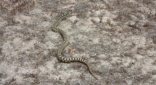
By mid-day, it was time to head to Green Mountain near Fallon. On the road to the highway, I spotted a big beautiful Gopher Snake. This would be my last campsite before heading home. The rocks here are called Wonder Stone.
After loading up on rocks and making camp, I was treated to a lot of F-18 fighters flying out of Fallon Naval Air Station. I had my only camping neighbor here, other than the campground. They were about a mile away. Man, I hate being crowded.
I really like my Hallmark Milner LX. It’s great for these kind of off-road adventures. I can set up camp fast, it’s comfortable, and it’s easy to get going in the morning.
Some facts: I drove 2,300 miles in eleven days. I spent $861 on 183 gallons of gas. For an eleven day vacation, it was a good deal in my book.